Welcome to our blog


We love to travel around the globe experiencing the various rivers and natural habitats. Our folding canoe allows us to pack up and paddle on any waterway in the world! Silently floating down a river has to be the best way of viewing the diverse life therein. We're thrilled that you're signing in to read about our paddling adventures and hope that you enjoy following along.

Diana and Brian Svelnis , Canada
paddlingoffthebeatenpath@gmail.com


Wednesday, August 15, 2012

Yukon River

Due to a number of requests Di and I are adding our photos of our August 2012 canoe trip on the Yukon river. The lead in to this trip starts in Dawson Creek, B.C. where we had planned to put onto the Peace river with 3 weeks worth of supplies for a paddle to Fort Vermillion, Alberta. After arriving at the tourist info center there, we learned that recent flooding along that river had scoured the river banks such that camping spots might be challenging to find. Upon studying maps and available information we came up with the Yukon river as an interesting alternative. So with our curiousity in the north still intact we decided to drive the extra 1500kms to Whitehorse, Yukon and paddle the Yukon river the 700kms north to Dawson City. The Robert Service Campground in Whitehorse is right on the Yukon river and they also provide security to leave your vehicle for however long you require. A very ideal starting point indeed! We found a booklet in a bookstore containing river maps and descriptions in Whitehorse and set off down the river with supreme confidence. Di's only concern being the Five Finger Rapids located at Carmacks at about the  300kms. mark.


           The booklet turned out to be extremely accurate and we could anticipate each potential campsite. This was the site of our first camp. Our second day saw us enter Lake Laberge, something like 50kms long.
            Conditions were mostly calm and it was 2 and a half days of paddling along the east shore until we were  back in the flow of the river.


.

              It doesn't take long to become aware of the rich history of this area. Glimpses of old log structures dating back to the late 19th century are not rare. Pilings used by the paddle wheelers that came up the Yukon river from the Pacific bringing supplies were also common along the shoreline.
              They would tie up at wood yards  where fuel was loaded for their steam engines. 


.  

 Eventually the lake ended and the water began moving again. The next couple of days were noted for the lively clip of our canoe along this part of the river as well as the beautiful clarity of the water.                          


  As you can see from this last picture some of the campsites were complete with picnic tables, firepits and even outhouses at some. We were surprised by the infrastructure we found all along the river. It seems that paddling the Yukon is one of the territory's premier attraction's. We encountered individuals and groups with and without guides every day. Thankfully there were plenty of campsites for all.                                            


       The Five Finger Rapids have an ominous reputation. Upon reading and talking to locals we were able to deduce that most of the deadly passages through the rapids occurred during spring run off over 100 years ago, usually with poorly built unmaneuverable log rafts manned by inexperienced miners. These granite pillars standing up in the middle of the river constitute the fingers and the rivers splits around them. Our literature suggested to navigate through the extreme east opening and we passed through with ease. The many hours we needed to discuss this passage will not be chronicled  here.


 With a huge sigh of relief we relaxed to enjoy our surroundings more and the wilderness of the north seeped into our soul.             


                This area grew from the discovery of gold in the Klondike valley. True wilderness went in every direction for many hundreds and even thousands of kilometers. The only routes through the mountains and bushland were the rivers. Log rafts and homemade boats and eventually paddlewheelers during the short warmer months. Dogsleds and horses on the frozen rivers during the long winters. As more miners and  entrepreneurs came to try their living in this climate a wagon road began to stretch along the river shore.               

          .                                              
                 Here, at a place originally called McKay's Crossing, a cable ferry and log hotel was built to offer comfort to the travelers on the tough trip between Dawson City and Whitehorse. The wagon road shortened the trip between the 2 communities by some 160kms by cutting between the bends of the winding  river.  We can only imagine what the word "comfort" might shore  have meant at the time.                        

                  
                                                                                                                                                                                      As we floated further north we felt civilization slipping behind us. We saw many moose, bear and mountain goats. We began to wild camp to avoid the possibility of other canoe paddlers setting up a camp beside us and disturbing our peace.                                                                                                                                                                                                                                                                                                                                                                              


                                            There's only one day we can recall a cold rainy morning which forced us to get off of the river and find shelter from the wind. Every other day showed us the best of the Yukon.


        This is a trip we can recommend to all levels of paddlers. The river has only a couple of small bumpy spots and the river speed and strength is never difficult to handle. Most paddlers fly into Whitehorse and rent a canoe from one of several outfitters in Whitehorse who will provide pick up service at your chosen take out point. This is a trip being done by many visitors to Canada from all over the world as well as folks from the entire country. We expected a remote solitary experience in the "far north" but we have not seen a more popular river yet anywhere in the world! That being said we have to admit it's popularity is deserved.                                                                                  


Wednesday, March 7, 2012

Mekong River 2012 (part 1 ) Ban Houay Xai to Luang Prabang

PADDLING THE MEKONG RIVER 2012

In 2009 we had a chance to view the mighty Mekong River from the town of Luang Prabang in Laos. We were so impressed that we started to think about taking our trusty pakboak canoe to Laos to paddle a portion of the river. On February 2nd, 2012 we will head for Thailand to start our expedition. We plan to cross Thailand overland to Chang Khong, situated on the Mekong river across from the border town of Houay Xai, Laos. After crossing into Laos we will paddle to Vientiane, a distance of about 750 km. We hope to have a couple of weeks at the end of our paddle to relax on the exotic beaches of Thailand and perhaps do some birding in the national parks.


Our first stop was Bangkok and we recommend that if you get a chance to visit that city you make it short. The air is so choked with exhaust fumes that our airways felt raw as we walked about getting our supplies. Walking was as efficient as any vehicle as the traffic would rarely move throughout the entire day.


The hotel we reserved was centrally located, quite stylish and excellent value. This first photo is from the roof top where there was a fabulous pool. Bangkok has an extensive canal network which is used by "boat buses" to transport people and goods.


After 5 nights we took an 11 hour VIP bus to Chang Rai in northern Thailand. Here we stayed 2 nights in a lovely garden resort.


From Chang Rai we hopped on a local bus for a 2.5 hr. ride to the border town of Chang Kong. The bus turned out to be older than us and the driver looked to be younger than our children. The license plate revealed that the bus was registered in 1950.


"Oh, Oh. What have I got myself into?"


The bus pulled out and after the driver's wife collected the fares we pulled in for gas. Both the driver and the bus turned out to be excellent and we had a surprisingly pleasant and interesting journey. At Chang Kong we took a tuk-tuk to the border post at the Mekong river and then were ferried across to Huoay Xai, Laos.
    
Humping the gear down to the ferry to Laos


Looking back towards Thailand


Houay Xai is the starting point for a popular 2 day "slow boat" trip to Luang Prabang. We, however, are redefining the term "slow boat". After clearing immigration we took a room at the Riverside Guesthouse which provided easy access to the Mekong. That evening we enjoyed a table top barbecue dinner on the hotel patio.


The next morning as we were putting together our canoe one of the hotel employees carried 6 large garbage bags down to the river and heaved the whole lot of them into the Mekong beside us. The shoreline was strewn with trash as using the river to carry the garbage away seemed to be standard procedure for the town. Nevertheless we packed our gear and began our expedition in high spirits.


River traffic was common with small private craft hugging the shoreline and slowboats and speed boats carrying passengers and goods. The kings of the river were the large scows carrying heavy cargo. The families that operated them lived on board in a 2 level house built on the stern.


We made ourselves amenable to everyone by smiling and waving a "Sabadee" and felt we were building a rapport with the other river pilots. Each day the return waves seemed to be more enthusiastic as boat operators came to recognize us.


The river felt very remote yet we saw people every day working on the river. They were collecting river weeds and periwinkles for food, doing laundry, panning for gold and bagging sand. There were many small children with them, either helping out or playing on the water's edge. We passed numerous remote primitive villages, mostly small, but occasionally a larger one serviced by a dirt road. A village with a road usually indicated a larger scale enterprise such as a teak farm, a fish farm, a sand collection site, or all of the above.

We also saw cattle, domestic Asian buffalo and goats wandering freely on the shore. They seemed to be on their own in the middle of nowhere. We figured there must be a small village hidden in the forest. We could hear lots of songbirds every day but rarely saw any birds.

Camping and stops for lunch or swimming was super easy on the pristine and soft sandy banks lining the river.


The river was fast and mostly flat. Some days we encountered a series of intense but short rapids. We ran some, lined others and portaged one with the help of some fishermen.


Occasionally we inadvertently made camp next to a local trail. Curious villagers that came upon us would simply sit down on the trail and stare. There they stayed until we offered them some food or water and then they became quite friendly. Communication was, of course only possible by signing.


Eight and a half delightful days after leaving Houay Xai we reached Luang Prabang for a scheduled rest and resupply stop. We were lucky enough to find a guesthouse up the Nam Khan river that had a trail down to the water.We are leaving tomorrow after 3 nights here. Our next entry should be in about 2 weeks when we hope to arrive in Vientienne.


Tuesday, March 6, 2012

Mekong river 2012 (part 2) Luang Prabang to Vientienne

In a way we were glad to leave Luang Prabang with it's thriving tourism industry and get out on our own once again. The river was calm and wide and we immediately noticed a huge decrease in river traffic. The road network is much more developed south of Luang Prabang, therefore the river is no longer the main transportation corridor. We found a great campsite that first night and this continued to be the norm.

We were thrilled to find a loaf of white bread and some real cheese in Luang Prabang, which meant we could have sandwiches for lunch the first few days. Yum!!

On our second evening we had one of the highlight experiences of the whole trip. We had just set up camp in what we thought was a secluded spot when 4 girls paddled up the river to check out the "falangs". They were very shy at first which they soon overcame upon receiving oreo cookies. They stayed a short time and then left. A little while later a group of 8 boys and girls, between the ages of 8 and 12 arrived on foot. We also put them at ease by handing out more oreos. When they were comfortable enough they began to entertain us with a demonstration of some typical village games. Our clapping and encouragement resulted in a more relaxed and friendly atmosphere. Brian taught them how to play hopscotch which they picked up right away. In the middle of the hopscotch game 3 of the older girls rejoined us. One of them had brought her exercise book containing handwritten english lessons. This lead to a spontaneous english practice session with the whole group. At one point the eldest girl looked into her exercise book and fixed on one word she decided to try. Sing, she commanded. Everyone agreed and we were on the spot for a performance. We selected Frere Jacques and followed that up with our ABC's. Some of the older girls were able to sing along with most of the ABC song. As darkness came they returned to their village. The next morning as we were packing up 4 girls returned to watch us. One girl in particular was intrigued as she watched Diana braid her hair. It made her day when Diana got up and braided the girl's hair. And then we were off while the kids ran along the riverbank waving, blowing kisses and shouting, "sing".


The Mekong river has many permutations, ranging from calm placid lake-like water to powerful rapids in narrow canyons. As it was impossible to get accurate information about the location of dangerous sections we had to always be vigilant and cautious. We tackled rapids in one of 4 ways depending on their severity. We ran them together, Brain ran them alone while Diana walked the riverbank, we lined the canoe along the shore or we portaged.


A portage, of course, means everything has to be carried!!


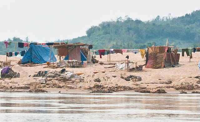
As the level of the Mekong drops during the dry season the newly revealed riverbanks become a beehive of activity. The whole length of the river we saw the Lao people panning for gold, extracting sand and gravel, fishing, growing crops, pasturing their animals, transporting logs and fish farming. As we got further south the scale increased both in numbers of people and the mechanization of the work. There were numerous tent camps set up along the river so that people could reside at their place of work.


Occasionally we saw temples, monasteries or immense golden Buddhist statues. Sometimes we heard the monks drumming before sunrise which added an ethereal quality to the morning.


The river eventually returned to being the border between Laos and Thailand. There was a noticeable difference in the level of development between the 2 countries. There was a constant flow of goods from Thailand to Laos at every ferry crossing between the countries. Thailand had some high-end guesthouses along the river.


When we got close to Vientienne the river became wide and shallow with lots of small islands and sand banks.


After 22 days of paddling we arrived at our final camp. We made it!!


The Mekong was the toughest river experience either of us had ever had. No matter how much research is done beforehand, the details of foreign rivers are never certain. We're thrilled with our accomplishment. The river was more than we anticipated but not more than we could handle!
Our interaction with the Lao people made our trip richer and more interesting. We now have an idea of what their lives on the river are like, and we enjoyed very much their calls of "sabadee" and their friendly waves as we paddled by.